 EMODnet Product Catalogue
Spanish Oceanographic Institute
Type of resources
Available actions
Topics
Keywords
Contact for the resource
Provided by
Formats
Representation types
Update frequencies
status
Scale 1:
-
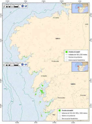
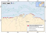
Spatial distribution in the evaluation area of Galicia of the habitat: Rocky infralittoral Sea Urchin dominated by "Paracentrotus lividus". Study of the spatial distribution of the species by marine demarcations attending the area covered by the species within the Marine Strategy Framework Directive. The cartographic representation of the species is interpreted as one of the indicators proposed by the Commission for the study of the biodiversity of species, habitats and ecosystems. This information is from the Spanish Marine Strategy, belongs to the good environmental condition and initial evaluation of the Marine Northatlantic Demarcation.
-
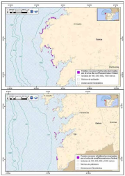
Spatial distribution in the evaluation area of Galicia of the habitat: Maërl beds. Study of the spatial distribution of the species by marine demarcations attending the area covered by the species within the Marine Strategy Framework Directive. The cartographic representation of the species is interpreted as one of the indicators proposed by the Commission for the study of the biodiversity of species, habitats and ecosystems. This information is from the Spanish Marine Strategy, belongs to the good environmental condition and initial evaluation of the Marine Northatlantic Demarcation.
-
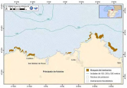
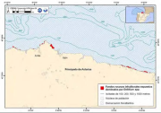
Spatial distribution in the evaluation area of Asturias of the habitat: Laminaria forest. Study of the spatial distribution of the species by marine demarcations attending the area covered by the species within the Marine Strategy Framework Directive. The cartographic representation of the species is interpreted as one of the indicators proposed by the Commission for the study of the biodiversity of species, habitats and ecosystems. This information is from the Spanish Marine Strategy, belongs to the good environmental condition and initial evaluation of the Marine Northatlantic Demarcation.
-
Spatial distribution in the evaluation area of Galicia of the habitat:Laminaria forest on infralittoral rock. Study of the spatial distribution of the species by marine demarcations attending the area covered by the species within the Marine Strategy Framework Directive. The cartographic representation of the species is interpreted as one of the indicators proposed by the Commission for the study of the biodiversity of species, habitats and ecosystems. This information is from the Spanish Marine Strategy, belongs to the good environmental condition and initial evaluation of the Marine Northatlantic Demarcation.
-
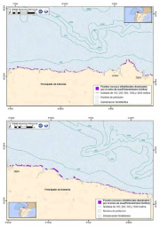
Spatial distribution in the evaluation area of Cantabria of the habitat: Rocky infralittoral exposed dominated by "Gelidium spp.ÔÇ£ in Cantabria. Study of the spatial distribution of the species by marine demarcations attending the area covered by the species within the Marine Strategy Framework Directive. The cartographic representation of the species is interpreted as one of the indicators proposed by the Commission for the study of the biodiversity of species, habitats and ecosystems.
-
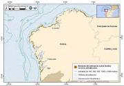
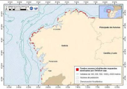
Spatial distribution in the evaluation area of Asturias of the habitat: Rocky infralittoral exposed dominated by "Gelidium spp." in Asturias. Study of the spatial distribution of the species by marine demarcations attending the area covered by the species within the Marine Strategy Framework Directive. The cartographic representation of the species is interpreted as one of the indicators proposed by the Commission for the study of the biodiversity of species, habitats and ecosystems. This information is from the Spanish Marine Strategy, belongs to the good environmental condition and initial evaluation of the Marine Northatlantic Demarcation.
-
Spatial distribution in the evaluation area of Galicia of the habitat: Rocky infralittoral exposed dominated by "Gelidium spp.". Study of the spatial distribution of the species by marine demarcations attending the area covered by the species within the Marine Strategy Framework Directive. The cartographic representation of the species is interpreted as one of the indicators proposed by the Commission for the study of the biodiversity of species, habitats and ecosystems. This information is from the Spanish Marine Strategy, belongs to the good environmental condition and initial evaluation of the Marine Northatlantic Demarcation.
-
Spatial distribution in the evaluation area of Asturias of the habitat: Rocky infralittoral Sea Urchin dominated by "Paracentrotus lividus". Study of the spatial distribution of the species by marine demarcations attending the area covered by the species within the Marine Strategy Framework Directive. The cartographic representation of the species is interpreted as one of the indicators proposed by the Commission for the study of the biodiversity of species, habitats and ecosystems. This information is from the Spanish Marine Strategy, belongs to the good environmental condition and initial evaluation of the Marine Northatlantic Demarcation.
-
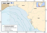
Spatial distribution along the southatlantic spanish coast of the habitat: High energy littoral reefs associated to Dendropoma petraeum. Study of the spatial distribution of the species by marine demarcations attending the area covered by the species within the Marine Strategy Framework Directive. The cartographic representation of the species is interpreted as one of the indicators proposed by the Commission for the study of the biodiversity of species, habitats and ecosystems. This information is from the Spanish Marine Strategy, belongs to the good environmental condition and initial evaluation of the Marine Southatlantic Demarcation.
-
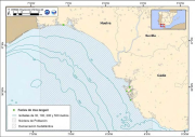
Spatial distribution along the southatlantic spanish coast of the habitat: Littoral muddy sand sediments associated to Uca tangeri. Study of the spatial distribution of the species by marine demarcations attending the area covered by the species within the Marine Strategy Framework Directive. The cartographic representation of the species is interpreted as one of the indicators proposed by the Commission for the study of the biodiversity of species, habitats and ecosystems. This information is from the Spanish Marine Strategy, belongs to the good environmental condition and initial evaluation of the Marine Southatlantic Demarcation.